
Santa Monica Neighborhoods
== Santa Monica Canyon ==
Adjacent to the [[Pacific Palisades]] and [[Sunset Boulevard]] facing out upon the [[Pacific Ocean]] is [[Santa Monica Canyon]]. An absolutely stunning neighborhood found below/North of San Vicente Blvd., in a luscious green canyon with fantastic views of the ocean and sunsets. With winding roads and steep canyon walls this small enclave shares more with wooded [[Topanga Canyon]] than the city of Santa Monica. Home to musicians, movie stars, and aging beach bums, [[Santa Monica Canyon]] is not, in fact, part of the City of Santa Monica at all. Rather, this misleadingly named neighborhood is part of the city of Los Angeles, and its Canyon Charter Elementary School is one of the most prestigious elementary schools in the [[LAUSD]]. The border between Santa Monica and the Palisades is Chautauqua Blvd.


== North of San Vicente ==
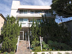
[[Image:Santa Monica Steps.jpg|thumb]]
[[San Vicente Boulevard (Santa Monica)|San Vicente Boulevard]] is the northernmost major street in Santa Monica. Homes north of San Vicente Blvd are among the most expensive in [[Los Angeles County]] and often contain views of the Pacific Ocean or the picturesque Santa Monica Canyon. La Mesa Street is one of the most expensive and least known in the city, planted with a dense canopy of rare Moreton Bay fig trees the street makes a picturesque walking location. Twenty blocks closer to the ocean the [[Santa Monica Steps]] are a popular set of 189 very steep steps that lead down into the canyon. Rather than being used as a convenient direct route from the Canyon Charter school to Adelade drive, they are more often utilized for intense workouts and are an excellent place for spotting sweating celebrities. Streets north of San Vicente are usually short and contain large gated homes. This is part of the 90402 zip code.
== North of Montana ==
South of San Vicente and north of [[Montana Avenue]] consist of larger family homes and lots. The streets in this portion of Santa Monica are Georgina, Marguerita, Alta, Carlyle, and Brentwood Terrace from 4th to 26th Street. Along with the area north of San Vicente and Santa Monica Canyon, this area constitutes the 90402 zip code. Houses north of Montana Avenue fetch among the highest prices per sf for houses and lots in the city of Los Angeles. It is an absolutely beautiful, quiet and interesting area to live in. The streets have pretty trees and well kept landscaping. The vitality of the neighborhood is kept alive by the interesting boutiques and restaurants along Montana Avenue. The most expensive homes are located just north of San Vicente on La Mesa Drive. Most of the lot sizes are {{convert|7500|sqft|m2}} on 50' X 150' lots. The Gillette's Regent Square tract, developed by [[King Camp Gillette|King Gillette]] - the razor blade manufacturer, are 60' wide lots.
This area is served by 2 highly regarded public elementary schools - Franklin School for the residents on 15th through the west side of 26th and Roosevelt for the families on 14th Street down to Ocean Ave.
During [[Halloween]], the streets here are famous for their prevalence of trick or treaters, parties, and sheer amount of people.
== Montana Avenue ==
[[Montana Avenue]] is home to two elementary schools, several condos, and dozens of upscale stores. There are three [[Starbucks]] (one inside Pavillions) two of which are located between 7th St. and 9th St., one [[Coffee Bean and Tea Leaf]], and one Peet's Coffee and Tea among several independently owned cafes and coffee shops. The businesses run from glamorous boutiques with only a few chain stores to neighborhood pharmacies and a [[Blockbuster Inc.|Blockbuster]]. Very pricey condos can be found mostly just south of Montana Ave. Montana Ave. is also home to [[The Aero Theater]] which shows classic movies and hosts filmakers after their films are shown. The theater is operated by The [[American Cinematheque]]. Every December and June the Montana Ave. Association hosts a neighborhood wide sale and festival where stores give holiday discounts, give free samples of food, or have clearance sales to make room for a new season of clothing.
== North of Wilshire ==
North of Wilshire, but South of Montana Avenue, is a primarily residential neighborhood. Laid out on a consistent grid of numbered streets, there are many mid-sized homes and condominiums. On its westernmost end this neighborhood includes a number of well preserved [[Victorian architecture|Victorian]] duplex houses otherwise unique in the city. Smaller [[craftsman]] era bungalows line the east-west avenues like Idaho, Washington, and California. [[Lincoln Middle School (Santa Monica, California)|Lincoln Middle School]] is on 14th Street and California Ave. At the corner of Washington Avenue and 22nd is the original [[Gehry House#Gehry_Residence|Gehry House]], a [[deconstructivist]] masterpiece that signaled a dramatic shift in Frank Gehry's architectural style. Real estate is exceptionally expensive in this neighborhood, albeit slightly less expensive than the more stately properties north of Montana.
== Ocean Avenue ==
[[Ocean Avenue]] is a major thoroughfare in Santa Monica that runs along the Palisades Park, with a view of the [[Pacific Ocean]]. Real estate is extremely expensive here, as all residences have a full view of the beach and Pacific Ocean. South of California Ave are several hotels, restaurants, businesses, and homes. The Santa Monica Pier is located at Ocean Ave and Colorado Ave.

== Downtown Santa Monica ==
Downtown Santa Monica is located south of California Avenue. The streets that make up downtown Santa Monica are [[Wilshire Boulevard]], Arizona Avenue, [[Santa Monica Boulevard]], Broadway, and Colorado Avenue from 2nd street to 14th street. The [[Third Street Promenade]] and [[Santa Monica Place]] are located in the heart of downtown. Many restaurants, tourist sites, and hotels are in downtown Santa Monica. In particular, Santa Monica Boulevard has an abundance of car dealerships.
== Ocean Park ==
[[File:Ocean Park Public Library.jpg|thumb|Ocean Park branch library, an original [[Carnegie library]].]]
Located in the southwest corner of Santa Monica is the Ocean Park neighborhood. This neighborhood has a mix of older smaller homes and apartment buildings and condos. Several housing towers are located along the beach. The area has a funky, artsy feel similar in manner to its neighbor Venice Beach. Many Santa Monica residents come to shop/browse on Main Street, home of many boutiques and restaurants. Main Street also hosts a weekly farmer's market on Sundays. SMASH (an alternative school) and John Muir elementary schools are located in the neighborhood. Olympic High, an alternative high school is also located in the area.
==Sunset Park==
Sunset Park is a residential neighborhood located between Pico Boulevard and the southern city limits and Lincoln Boulevard and eastern city limits. It is composed primarily of single-family housing. Most of the homes are small one-story houses built in the 1940s for workers at the [[Douglas Aircraft Company|Douglas Aircraft Factory]]. Remodeled or rebuilt homes are upscale.
Sunset Park is part of the Santa Monica-Malibu Unified School District. Will Rogers and Grant elementary schools and John Adams Middle School are located in the neighborhood. [[Santa Monica College]], a two-year community college, is also located in Sunset Park.
[[Santa Monica Airport]], one of the busiest single-runway airports in the nation, is located along the southern borders of the neighborhood.
== Thoroughfares ==
Major east/west thoroughfares in Santa Monica are [[San Vicente Boulevard]], [[Wilshire Boulevard]], [[Santa Monica Boulevard]], [[Olympic Boulevard (Los Angeles)|Olympic Boulevard]], [[Pico Boulevard]], and [[Ocean Park Boulevard]]. All of these streets are four lanes in width. Wilshire Blvd and Santa Monica Blvd contain the most traffic. It is fairly easy to travel east/west in Santa Monica.
Traveling north/south in Santa Monica is considerably slower and more difficult. Most north/south streets in Santa Monica end relatively quickly or fail to yield traffic lights at intersections, making travel difficult during rush hour. The major streets are [[Ocean Avenue]] and [[Lincoln Boulevard (Southern California)|Lincoln Boulevard]] which goes to [[Los Angeles International Airport]]. These two streets are mostly four lanes and considered major thoroughfares. In particular, Lincoln Blvd becomes congested since it is a main route that leads to the [[Santa Monica Freeway]], Venice, Marina del Rey, and the Los Angeles International Airport. A number of smaller residential streets allow north/south travel through Santa Monica. These streets are: 7th Street from Olympic Blvd to the [[Pacific Coast Highway (California)|Pacific Coast Highway]], 11th Street from San Vicente Blvd to Marine Street on the border of Venice, 14th Street and 20th Street from San Vicente Blvd to Ocean Park Blvd, and 26th Street from San Vicente Blvd to Olympic Blvd, where most traffic diverts to Cloverfield Blvd. 17th Street runs from San Vicente Blvd to the entrance of [[Santa Monica College]] on Pico Blvd. All of these streets are only two lanes (with the exception of a brief portion of 20th Street). However, all of these streets encounter traffic lights at all intersections, making travel plausible. One alternate route to reach the Santa Monica Freeway going eastbound is to take Cloverfield Blvd, a short four lane street that begins off [[Santa Monica Boulevard]]. To go westbound, the alternate route is 20th Street.